Chunks of concrete have fallen off the southbound Hwy1 bridge over Toro Creek, causing corrosion of the rebar inside. Caltrans plans to replace the bridge starting sometime next spring. Photos courtesy Caltrans
By Neil Farrell
T
he Coastal Commission has approved a permit to allow Caltrans to replace the southbound side of the Hwy 1 bridge over Toro Creek in north Morro Bay, a project that could bring several side benefits to the folks who frequent Dog Beach.
Caltrans already replaced the northbound side bridge a few years ago bringing that 1930s-era structure to modern size and standards. It meant the removal of one of the few remaining original highway bridges dating to the 1930s, when Model Ts roamed the largely unpaved roads, but greatly improved safety for the heavily pedaled bicycle route.
Then the southbound side was discovered to have corroded badly, with cracked and offset supports in the creek bed and so the State decided that newer bridge, built in 1962, had to be replaced as well.
“The existing southbound Toro Creek Bridge,” reads a project description on the Dist. 5 website, “has poor bridge health due to non-recoverable corrosion on the columns, abutments, and superstructure, and replacement of the structure is needed to resolve the issue.
“The existing bridge has bridge railings that need to be replaced with bridge railings that meet current Manual for Assessing Safety Hardware standards. The existing outside shoulders need to be widened to standard width to decrease off-tracking vehicle collisions and facilitate the passage of bicycle traffic.”
Cost for just the bridge construction are listed at $15.26 million, and Caltrans’ Project Manager, Nicholas Heisdorf, said that was still a good number.
Heisdorf said while they were at the Coastal Commission review, they got the final design work done and have also finished up the environmental review, which was done with a Mitigated Negative Declaration or Neg-Dec. That means that whatever environmental impacts anticipated from the project are mitigated through conditions in the permit.
He said the plan now is to send the project up to Sacramento for funding from the California Transportation Commission (CTC), the governing body of Caltrans and most of the transportation-related projects in California. If it goes as planned, they should be able to get the funding approved in October and be out for bids by January. Normal contract requirements give the contractor two months to get up and running, so Heisdorf said they should start construction some time early next spring.
The Coastal Commission’s report estimated a 1-year construction but Caltrans’ posted schedule on the website gives it an expected completion date of June 2028.
Just as with the north side bridge project, traffic will be moved across the median and merged so that both directions go over the new northbound bridge during construction.
That will set up a short bottleneck for traffic in both directions as they merge onto the single bridge.
The entire bridge will be demolished and a new 130-foot bridge built. It would be the same length as the old bridge, but a bit wider on the shoulders to better accommodate bicycles.
Ironically, another project, being pursued by the County, will build a dedicated bicycle path to the west of the highway overlooking the beach. That too will require a long bridge over Toro Creek, albeit one made for bicycles and pedestrians, not hundreds of cars and trucks a day.
And the project calls for the continuation of the small parking area on the west side of the highway where folks park to bring their dogs to Dog Beach, the only off-leash dog-friendly public beach in SLO County. The City of Morro Bay owns Dog Beach.
There is room for up to 50 cars to park along the roadway, between Hwy 1 travel lanes and the highway safety fence. It’s a very popular spot.
“The parking areas along the highway, both north and south of the bridge,” the Coastal Commission report said, “currently allow parking for approximately 50 vehicles, and are quite popular, especially with dog owners. About one-half of the parking spaces would be blocked during the project’s estimated one-year construction period.”
The Commission’s permit also anticipates the County building a regional park on the old Chevron Estero Marine Terminal Shore Plant, the flat lands adjacent to the highway where first Standard Oil and later Chevron controlled the uploading of crude oil onto tanker ships moored in Estero Bay.
The marine terminal was in operation from 1929 to 1999 when it was closed in favor of a direct pipeline from Central Valley oilfields and the San Ardo oilfield in Monterey County to Southern California refineries.
Over the ensuing years several of the parcels have been purchased and put into public ownership through collaborative efforts of state and local conservation groups and governments and eventually the County plans to put in the regional park on the flatlands of the shore plant.
“There have been a variety of land conservation efforts over many years in the project area,” the Commission report said, “including public and private land conservancy acquisitions, with the long-term intent of creating a public park inland of the Highway [which some have called ‘Toro Creek Park’] that would be part of a larger and contiguous protected open space area extending between Cayucos and Morro Bay.
“As such efforts come to fruition, there is also a desire to connect such future park areas inland of the highway to the beach and the ocean.”
But having to cross a busy 4-lane highway could be a problem, so the Commission and Caltrans agreed to remedy the matter.
“The Highway 1 bridge underpasses provide a potential opportunity to make such a connection without requiring users to cross over the highway. Accordingly, Caltrans has agreed [and this CDP requires them] to allow public access under the bridges and to work with the County to develop a public coastal access connection for pedestrian access between the inland parklands and the beach via the bridge underpasses or through some other longer-term identified measure.”
Until all this happens, the permit requires Caltrans to allow people to walk under the bridges and access the beach, though the pathway will not be improved.
Caltrans’ permit also requires them to work with the County to make improvements near Dog Beach, to include a second opening in the safety fence for access to the beach. Right now, there is just one gate on the north end of the parking areas.
They will also work up plans to improve that dirt parking area “into a more formal beach parking/access area, with the goal of making it more accessible, functional, and safe for users of the County’s popular Morro Bay Dog Beach.” That work would be done after the bridge project is finished.
“As is, this area is unpaved and rudimentary, and there are public safety concerns as users enter and exit the parking area from a fast-moving highway or walk along the highway and parking area.
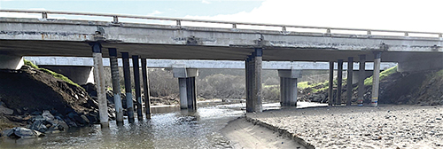
The southbound Hwy 1 Bridge over Toro Creek is slated to be replaced starting sometime next spring.
“There is the potential to create safer parking and to provide a modicum of public amenities in this area in a way that would increase its public utility.”
The Commission added one more item to its lengthy list of conditions — the new bridge must anticipate sea level rise caused by climate change.
Heisdorf said they are required to build the new bridge in anticipation of what he called “The perfect storm,” i.e. anticipating a combination of king tide, heavy rain runoff form the huge Toro Creek watershed, and a rise in sea level. They agreed to raise the level of the new bridge 2 feet, he said, and to do another study on sea level rise.
It was a condition for their northbound bridge, he said, to do a study and they partnered with Cal Poly. He said they conservatively chose 2 feet as the additional height to raise the new bridge to compensate for what is essentially a worst-case scenario, a perfect storm of catastrophes.
It’s similar to a situation from Hwy 1 at the old Piedras Blancas Motel, which sits overlooking the ocean north of the Piedras Blancas Light Station.
Occasionally, waves crashing against the shore below the road, which basically sat at sea level, would wash onto the roadway.
So, Caltrans agreed to swing the road inland, in what amounts to a detour to avoid the short stretch of wet road.
So, while motorists will have the renewed hassle of merging four lanes of traffic onto one, 2-lane bridge for a while, on the other side they should come out with a safer bridge and improvements to the access for Dog Beach and further clearing the way for a future County Regional Park as well.