A look down South Bay Boulevard from State Park Road shows the depth of the flooding. Photo courtesy Cal Fire
For over 40 years South Bay Boulevard, the sole direct pathway linking Morro Bay and Los Osos, flooded just about every winter at the infamous “Twin Bridges.”
In the mid-1990s, and after many years of trying by various government agencies, the City of Morro Bay finally built the Chorro Creek Bridge.
It’s been smooth sailing ever since, until Jan. 8-9. That’s when a major storm system blew into the Central Coast, indeed the entirety of California, and dumped nearly 5 inches of rain here in a little over 24 hours.
The storm wreaked havoc from San Miguel, where a 5-year old boy was swept away and lost, down into Santa Barbara County, which sustained extensive storm damage ranging from washed out roads, mud slides in Montecito to huge sinkholes that threatened to swallow entire homes.
The storm, which the City of Morro Bay said was equal to a once in 300-year event, left a swath of devastation and sorrow.
It was if the March 10, 1995 mega storm had recurred, as many of the flooded areas in Mo0rro Bay were also underwater in that monster storm that saw 13 inches of rainfall overnight.
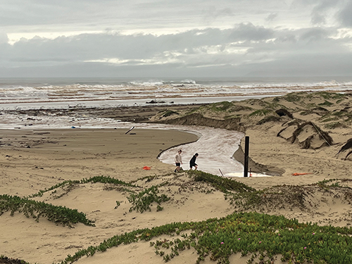
South Bay Boulevard Floods

Photo courtesy Cal Fire
And for the first time since Twin Bridges was replaced, Chorro Creek overflowed its banks and inundated South Bay Boulevard at State Park road, completely closing South Bay.
That closure was coupled by a cascade of floodwaters from a swollen San Bernardo Creek that flooded Hwy 1 so high that water was flowing over the top of the concrete center divider, and washing across the westbound lanes and down onto farmland alongside Quintana Road.
Quintana was also closed, and after rock slides closed Hwy 41 out towards Atascadero, Morro Bay almost became an island, with no getting in or out, unless one wanted to brave the storm, drive over the Cuesta Grade all the way to Paso Robles and then over the hill on Hwy 46 West, then south on Hwy 1.
Morro Creek Flooding
Morro Creek, normally a trickle of water that doesn’t make it all the way to the ocean, became a torrent, that overflowed at the Main Street bridge.
That caused a major flooding event along the 1500-1700 blocks of Main St. The floodwaters overwhelmed several businesses along that stretch of Main Street including Wee Shack, Estero Bay Glass, Morro Bay Antiques, and Central Coast Cart & Scooter. Plus several people who live in that area were also evacuated — some by kayak piloted by volunteers — and had their homes damaged by flooding.
Public Works Director, Greg Kwolek told ESBN, “The flood was caused by a high volume of water in a short amount of time going to the creek.” He added that the water washed additional debris into the creek channel, “which certainly did not help. But this did not cause the flood nor was there any plug” at the Main Street bridge.”
South Bay Rescue
According to Cal Fire EMS Battalion Chief Rob Jenkins, rising floodwaters on the Chorro Creek Bridge trapped two vehicles that were bound for Morro Bay.
Another motorist in a pick-up truck rescued a man who was trapped in a car, Battalion Chief Jenkins said. The other vehicle, with an 86-year-old woman inside, wasn’t as lucky.
B.C. Jenkins said the floodwaters rose so quickly, the truck was unable to go back in to get her.
So Cal Fire brought in a swift water rescue team in a boat and they were able to reach her. A Coast Guard helicopter came in to airlift her out of danger and she was ultimately taken to a local hospital.
Quintana Road Submerged
Numerous vehicle parked on Quintana Road at the Bay Pines RV Park, were inundated with water, as the Chorro Flats floodplain overflowed its berm and the entire area around South Bay and Quintana was flooded.
Kwolek said, “The City’s observation was that the flood on Quintana and South Bay resulted from high water levels from Chorro Creek coinciding with the high tide.”
Residents along Chorro Creek Road were hit especially hard as the various creeks that converge along Chorro Valley into Chorro Creek for the final run into the National Estuary overwhelmed the area.
Homes, outbuildings, farmlands were all flooded by the immense amount of runoff and days later, and, with another storm expected over the Jan. 13-15 Holiday Weekend, there wasn’t much relief in sight for those folks.
And their only road in or out was still over-flowing with runoff a week after the big storm hit.
Vista Court Washout

from a broken retention pond levee.
Perhaps the hardest hit area of the Estero Bay was the Vista Ct., neighborhood in Los Osos, where a storm water retention pond failed and sent a torrent of mud and debris down into a residential neighborhood.
No one was killed in the devastation that saw mud and water 3-feet deep enter numerous homes
The pond, which is connected to the Cabrillo Estates neighborhood on the hills above Vista Ct., was reportedly inspected by the Community Services District early Jan. 10 and was fine, according to the CSD quoted in news reports.
But by about 4:15 p.m. all heck broke loose. According to B.C. Jenkins, the eastern wall of the pond gave way and opened up a breech in the levee.
“That let all the water out all at once,” B.C Jenkins said.
The slurry of mud, water and debris swiftly flowed downhill towards Vista Court and B.C. Jenkins said the mudflow affected some 15 homes on Vista Court and flowed down further damaging another five homes.
In the immediate aftermath, B.C. Jenkins said the County “tagged” five homes due to the damage, three with red tags, meaning they were uninhabitable and two yellow, which he said allows the residents to enter and salvage whatever they can.
Such floodwaters are not very clean and when they inundate a home, it triggers extensive drywall and flooring removal and replacement. B.C Jenkins said one problem that has arisen already is that insurance companies are calling this a flood and unless someone has “flood insurance” they could get stiffed by their insurance companies.
Community to the rescue
After the flood, neighbors of the Vista Court folks turned out in droves, bringing shovels and brooms and rolling up their sleeves to help their neighbors dig out of the muck.
B.C. Jenkins said, “There was a big turnout of people who came to help. They turned out in droves.” He noted that a social media group, “Support Los Osos” put the word out that folks needed help and the community responded. A California Conservation Corps group also came to help and the CSD brought in several port-a-potties, he said.
CSD Maintained the Pond

Photo by Becka Kelly
The Community Services District was responsible for maintaining the retention pond, B.C. Jenkins said. But it was built many years before and was reviewed and permitted through San Luis Obispo County, as part of the original Cabrillo Estates subdivision.
That has the LOCSD board meeting to discuss their potential liability with this catastrophe.
Sewage Spilled
In Morro Bay, the big storm caused sewage to flow out of a manhole on Atascadero Road outside the City’s old sewer treatment plant.
“The area,” the City said in a news release, “is located in a flood zone with one of the lowest elevation points within the city. Flooding waters infiltrated into the sewer collection system causing approximately 9,900 gallons of highly diluted sewer water to overflow out of the top of a manhole into Morro Creek.”
Photos of the area during the storm show the intersection about 4-feet deep in floodwaters, with several pieces of heavy equipment, owned by Anvil Builders, the company installing the new conveyance system for the City’s Water Reclamation Facility Project.
Thankfully, the new treatment plant up above South Bay Boulevard was working at the time and there was a minimal amount of flow going to the old plant, which also got flooded. The old Waste Water Treatment Plant hasn’t been treating sewage since last November when the new plant started up.
“The recent storm event,” the City said, “resulted in the WWTP and the Corporation Yard being inundated with 3-4-feet of storm water from the flooding of Morro Creek.”
The City is working with County Environmental Health and the Regional Water Quality Control Board on the spill, which was one of several that occurred in SLO County due to the storm.
The flooding on Atascadero Road closed the street for several days while clean up was underway. The City put out an advisory warning people to stay clear of the area.
WRF Saved the Day
According to the City, it’s a good thing the new WRF treatment plant was up and running or the flooding on Atascadero Road would have been so much worse.
“Based on observed water levels,” the City said, “preliminary analysis of the flood event that occurred in Morro Creek indicates that flooding exceeded the threshold for a 100-Year and may have approached a 500-Year Flood Event.
“Had the new Water Resource Center not been operational, all of the City’s wastewater at the old WWTP would have been exposed to catastrophic inundation.”
That new treatment plant, which has been under construction since May 2020, came through its first big test.
“The WRF,” the City said, “readily handled the storm and sewer flows that are normally only 600,000 gallons per day, but increased to approximately 10-times higher, peaking at over 6 million gallons per day.
That huge jump in the flow was caused by sewer collection pipes that have for many years, been greatly infiltrated during big storms, flowing into the pipes under pressure from high groundwater levels.
The old collection system, most of which remains in use, is gravity-flow and the new conveyance system, which moves raw sewage from the old plant on Atascadero Road to the new one, some 3.5 miles away, is a force-fed system and under pressure from the inside.
The WRF plant included extensive storm drainage work too, making use of interior retention ponds that recycle the rain into the treatment plant, and a large drainage ditch running along the east side of the plant.
Dumpsters, Sand Available
The City said it has placed dumpsters and sand at multiple locations in the city for residents to dispose of ruined belongings and to fill sandbags, because the winter isn’t over yet and with the ground now saturated, should another big storm hit, there’s nowhere for the water to go.
Sand can be found at the City Library parking lot off of Shasta Avenue and at Cloister Park parking lot.
Sandbags can be purchased at Miner’s Hardware or any other hardware store. The City posted a map of the locations for the dumpsters and the sand, see: www.morrobayca.gov/DocumentCenter/View/17380/Morro-Bay-Dumpster-and-Sand-location-Map.
Help Promised
California Gov. Gavin Newsom declared SLO County a disaster area, one of several counties that were so designated; and President Biden declared a federal disaster, which presumably opens the area up to federal disaster relief, normally processed through the Federal Emergency Management Agency or FEMA.
The Morro Bay Chamber of Commerce is working to assist hard-hit businesses with filing claims for relief. “We are advocating on behalf of our business community,” the Chamber said, “with local, state and federal representatives. Follow the SBA’s social media channels — we have been told that program availability would be announced there first.
SLO County wants people to report any damage they sustained to their property from the big storm.
“For access to the most up-to-date information throughout this storm and any other emergency in our county,” the County said in a news release, “visit readyslo.org, or you can call our Phone Assistance Center from 8:30 a.m. to 5 p.m. Mondays through Fridays. The phone number is: (805) 781-5678.”
Damage Info Sought
SLO County is trying to help those affected by the storm and has forms and other assistance posted on a special website.
“If your home or other private property was damaged in the major storm that hit Morro Bay on 1/9/2023,” the City of Morro Bay announced, “please report that to SLO County at: www.recoverslo.org (through the form provided on the website).
“The Federal Emergency Management Agency (FEMA) has declared an emergency in SLO County for that storm and may provide assistance for storm damage. The form requests contact information, as well as information about the specific damage to private property and estimated cost.”
Pols Visit the Area
Morro Bay and Los Osos were two of the stops made by Congressman Salud Carbajal, and Dist. 30 State Assemblywoman Dawn Addis, who along with Dist. 2 County Supervisor Bruce Gibson, were among the officials who toured flood damages areas of Estero Bay on Jan. 16.
The pols visited with residents and business owners who lost so much in the storm, lending a sympathetic ear and promising as much help as possible.
Meanwhile, cleanup on Main Street continued through the end of last week, a full 10 days after the floodwaters drained off and left hundreds of tons of mud and debris that had to be scooped out with skip loaders and hauled away in dump trucks.
And surveys of the damage done to harbor facilities was being conducted. Early indications are that several City-owned docks and other facilities sustained damage and one sign at the launch ramp was blown over and reduced to splinters.
A Little Comic Relief
While the misery was compounding daily from this storm-of-the-century, someone provided a little comic relief, installing several duck decoys and one large Canada goose in a small pond that formed in a low spot on Main Street at Radcliff.
The decoys amused a town that celebrates the Martin Luther King Holiday with the Annual Winter Bird Festival. More than one interested birder was seen snapping photos of the decoys.
And the City’s BMX bike park along Main Street, which has its hills and dales fashioned of compacted dirt and clay, seemed to sustain little damage from the torrential rains. Indeed, except for some fencing that was dug up and strewn across the bike park, it appeared to have survived the flooding intact.