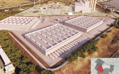
Rendering shows the layout of a proposed 48-lot subdivision proposed for a 10-acre parcel on Panorama Drive in Morro Bay.
The City of Morro Bay is preparing for a proposed subdivision in North Morro Bay at the site of a former Navy fuel depot, and neighbors of the property are not happy about it.
The Planning Commission on Nov. 7 had its first look at a proposed subdivision of the 10-acre vacant property located at 3300 Panorama Dr. That’s the cite of the former Defense Fuel Support Point or DFSP, Morro Bay that closed over 25 years ago and was cleaned up only recently.
That cleanup job involved removal of two 5.5 million gallon fuel tanks and a 100,000-gallon water tank, plus a slew of piping.
Now, the owner wants to subdivide the property into 48, single family lots, with accompanying interior roads and other amenities.
The project, designed by RRM of San Luis Obispo, is proposed to have five different floor plans for the homes with lot sizes ranging from 2,850 to 6,000 square feet. The total parcel covers about 10.9 acres but a 50-foot setback from a seasonal creek on one side will reduce the available building area.
Built in the 1960s to accept jet fuel offloaded from tanker ships anchored in Estero Bay, the facility piped the fuel all the way to Lemoore Naval Air Station (some 96 miles) via an underground pipeline. It operated until 1996 when a direct pipeline to Lemoore NAS was completed and shipping JP-5 fuel was no longer needed.
The federal government cleaned up the site as best it could and then sold it at public auction, garnering just $1.5 million in the sale. The purchasers were Rhine LP and Morro94.

The commission’s task was to offer recommendations to the property owners so they can alleviate concerns or make changes before a formal application for a subdivision map is made. It’s a relatively new concept this idea of commenting on the project before a project really exists, and designed to iron out differences and alleviate concerns before it all goes public. The idea is to allay concerns and satisfy requirements going in rather than have to go back time and again to the proverbial drawing board.
Though it’s all an old fuel depot, the parcel, one of the largest within the City Limits, is diverse with over a half-acre of environmentally sensitive habitat (a creek); almost an acre of required ESHA buffer; some 3.59 acres of developable lots; some 4.2 acres of common areas (roads, sidewalks, utility easements, etc.); for a total buildable area of 9.37 acres.
Once review of the proposal begins in earnest, it’ll have to get a Conditional Use Permit, a Coastal Development Permit and a Vesting Tentative Tract Map, a process that could take a couple of years or longer and will almost certainly include an appeal to the Coastal Commission, given the location of a coastal creek running down the northern side of the property. Some of the site is on a steep slope as well.

Rendering by RRM Design of SLO shows what the finished neighborhood on Panorama Drive would look like.
“The site includes steep slopes in the south and east portions of the site,” reads the City’s report, “some with landslide potential.”
In the General Plan update that was completed and certified in 2021, this property is zoned “Moderate Density Residential,” which allows for 4.1 to 7 dwellings per acre. That means the proposal is asking for fewer lots than the zoning would allow.
“This 10-acre parcel,” the report said, “is zoned to a lower density than the surrounding neighborhood, which is all Medium Density Residential, allowing 7.1 to 15 dwellings per acre (about twice the density of the subject parcel).”
The size — 48 lots — places the project within the City’s “inclusionary housing” requirements, which means they have to set aside 10% of the lots — five total — at affordable costs, a number to be determined later.
“The City of MB will determine the affordability level,” the report said, “likely to be ‘lower income’ levels which is 50%-80% of area median income. This equates to a home buyer or renter with approximate annual income levels between $41,000 and $65,000, which means that the rent or mortgage and related costs to the buyer/renter would need to be 30% or less of their total income.”
The City is currently doing an environmental review of the proposal that will delve into several potential areas — Aesthetics, Biological Resources, Cultural Resources and Tribal Cultural Recourses, Hydrology, Hazards and Traffic Impacts. It looks like the project may require a full environmental impact report.
Neighbors, in letters sent to the planning commission expressed concern for everything from the location of overflow on-street parking, to landslides, high density, potential flooding, increased traffic on narrow streets, and tree removals.
As to the landslide potential, Community Development Director Scot Graham said, “The developed footprint is outside the slide area. Slide area will be a park/open space area.”
The hillside all along Panorama Drive starting at Del Mar Park, is subject to moving during very wet winters. Indeed, on more than one occasion, homes in the general area have been damaged when heavy winters have dropped over 30-inches of rain in a season and the hillside starts to move. Some neighbors fear a catastrophic landslide could occur.
Though the overall property is relatively flat, there are sizable containment berms that were used to surround the fuel tanks and Graham said the plan was to bring in a whole lot of fill dirt.
“The tank areas are flat,” Graham said, “with exception of the berms. They were planning on bringing in 87,000 cubic yards of fill, but the community didn’t like that and neither did the Planning Commission. PC requested that they reduce the amount of fill that is to be imported.”
The property is an old fuel depot, and if history holds, these types of sites are often contaminated, including with cancer-causing chemicals. Is the site clean?
Graham said, “They are still waiting for final sign off from County [Environmental] Health. This will get sorted out as part of the environmental review.”