This map from NOAA shows the new preferred boundary of the proposed Chumash Heritage National Marine Sanctuary, which cuts out Morro Bay, Cayucos and the Harmony Coast from the sanctuary.
The Federal Government has taken a big step in the quest to establish a National Marine Sanctuary in local waters, but the proposed boundaries have taken a dramatic turn away from Morro Bay and Cayucos.
The National Oceanic and Atmospheric Administration or NOAA formally proposed the “Chumash Heritage National Marine Sanctuary” covering hundreds of square miles of the Central Coast from SLO to Santa Barbara Counties.
The Sanctuary was first proposed in 2015 by the Northern Chumash Tribal Council to honor the Native American group’s connection with the ocean in their traditional homelands.
NOAA said the designation is “to manage, interpret, and protect the area’s nationally-significant history and underwater cultural and natural resources. Through research, education, and community involvement, NOAA would work to foster long-term conservation and public awareness about this unique area,” reads a fact sheet put out by the agency.
The original idea was to establish a new sanctuary that would start where the Monterey Bay NMS ends at Cambria and stretch down to Point Conception close to the start of the Channel Islands NMS.
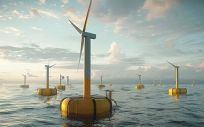
But NOAA changed the boundaries mainly because of proposed offshore floating wind farms being studied now for an area off the coast of San Simeon.
Now the northern edge of the proposed sanctuary would start at Montaña de Oro, specifically Hazard’s Reef (offshore from Hazard’s Canyon), and extends down nearly to Goleta in Santa Barbara County.
That cuts Morro Bay, Cayucos and the Harmony Coast, about 60 miles of coastline, out of the sanctuary’s promised protections. But that is a “preferred” boundary that the agency put out and not set in stone yet, as the agency starts taking public comments.
They picked the new boundaries, according to NOAA because it would be, “most manageable while simultaneously maximizing the principal resource protection purposes for the sanctuary. The preferred boundary achieves several objectives:
• Allows NOAA to focus its management on significant areas and natural resources, including offshore features like the Santa Lucia Bank and Rodriguez Seamount, in to shore to include kelp forests, sandy and rocky reefs and other areas;
• Allows a focus on areas historically important to the Chumash Tribe and natural resources important to their heritage;
• Removes an area where a large number of subsea electrical transmission cables from offshore wind leases to the Morro Bay area that would likely be unprecedented in a national marine sanctuary; and,
• It ameliorates concerns raised by several bands of the Salinan Tribe regarding naming the sanctuary “Chumash” in that area which they identify as being part of their ancestral homeland.
The Salinans and Chumash have long been in dispute over the Morro Bay and Cayucos Coasts, with each claiming it as an ancestral home. The Chumash down in Santa Ynez are the officially recognized Chumash Tribe by the federal government.
One issue not addressed by NOAA’s fact sheet is that the name “Chumash” is trademarked by the Chumash Tribe down in Santa Ynez that owns a casino/resort.
The Sanctuary’s name has apparently been controversial from the start.
“The sanctuary nomination from July 2015 that ONMS [Office of National Marine Sanctuaries] accepted into the inventory proposed calling the new sanctuary “Chumash Heritage.” When NOAA initiated the designation process in November 2021, it asked for public input on many considerations, including what the new sanctuary should be named.
“Public comments received at that time were overwhelming in favor of maintaining the proposed name, although other Indigenous communities in the broader region have objected to the name.”
NOAA has apparently taken a stand. “With the publication of the draft designation documents,” the agency said, “NOAA is proposing to designate the area identified in the Agency-Preferred Alternative as a national marine sanctuary named ‘Chumash Heritage.’ Members of the public are welcome to comment on the name and all other elements of the proposed sanctuary designation.”
Cutting Morro Bay and Cayucos out of the designation is apparently because of the proposed wind farms, which are planning to be sited on about 376 square miles of ocean, up to 30-miles offshore, some 57 miles northwest of Morro Bay.
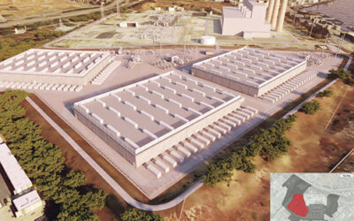
In addition to the massive turbines, each will have to have a buried power cable to bring the power in, combining at floating substations that will be located somewhere between the wind area and Morro Bay, where the power is expect to come ashore and connect to the state power grid at the closed Morro Bay Power Plant.
There are three companies that won lease sales last December and they are now studying the environmental impacts under the National Environmental Protection Act or NEPA.
NOAA has apparently decided that such structures and activities like trenching for the wires, don’t fit with the conservation mission of Marine Sanctuaries.
Also, the sanctuary program has traditionally avoided areas with sewage discharges, as was done with the boundaries of the Monterey Bay NMS that cut out a bid patch off San Francisco and its ocean outfall.
Both Morro Bay and Cayucos recently completed new treatment plants and treat their wastewater to a tertiary level before it’s discharged.
Morro Bay is working on recycling that discharged, highly treated wastewater and Cayucos hopes someday to return its treated wastewater directly into Whale Rock Reservoir, where all of Cayucos’ drinking water is stored.
But the wind farms are a special problem. “The Agency-Preferred Alternative for potential designation as a national marine sanctuary excludes the geographical overlap of the Morro Bay Wind Energy Area,” NOAA said. “This proposed boundary excludes a wide area [area between the proposed sanctuary and Monterey Bay National Marine Sanctuary] in which subsea electrical transmission cables and floating offshore substation(s) could be installed to connect the Morro Bay Wind Energy Area to the electrical power grid at Morro Bay.”
Another federal agency, Bureau of Ocean Energy Management or BOEM “estimates there could be up to 30 cables, and NOAA is concerned this may present a level of impact that would likely be unprecedented in a national marine sanctuary.”
NOAA pledged to continue to participate in BOEM’s wind farm planning but the State is on the move too. “Separate from the Morro Bay Wind Energy Area,” NOAA said, “the State of California is reviewing separate potential offshore wind proposals within the state waters of the proposed boundaries for Chumash Heritage NMS.” State waters are from shore out 3 miles, with federal waters going form 3 miles out to 200 miles offshore.
Locally, Estero Bay News sent inquiries to several local people including all of the city council members asking their reaction to having Morro Bay excluded from the sanctuary.
Dist. 2 County Supervisor Bruce Gibson, who has been a supporter of the CHNMS since the start said, “I’m excited to see the proposed designation published. This is a huge win for our coast and the protection of so many important resources.”
He too is concerned about the boundary change. “The gap in the sanctuary along the SLO County North Coast is significant and should be addressed, as these waters are equally worthy of this protection. I understand the issues surrounding offshore wind that were part of the published proposal and look forward to working with agencies, elected officials and other stakeholders to find solutions to closing the gap and protecting the entire SLO County coastline.”
Former City Councilwoman and environmental advocate, Betty Winholtz, was disappointed at the change. “I am surprised that the Harmony to Hazard Coast is carved out of the proposed Sanctuary. Residents of the North Coast have consistently supported a Sanctuary for the protection of our fishing grounds and prevention of offshore oil development. I think the carve out demonstrates the long arm of the Governor in influencing policy at the federal level.”
Local commercial fishermen have never supported the sanctuary designation. “We MBCFO [Commercial Fishermen’s Organization] are not happy at all as we see the powers that be cut up the ocean area around us for use by the government or the foreign governments that have leased our waters,” Morro Bay fisherman Jeremiah O’Brien told EBN. “The cables are not compatible with sanctuaries, so they just move over, no problem, it is sure they will achieve their agenda no matter what stands in their way.
“The move was to accommodate offshore wind, not fishing efforts. The Sanctuary was a problem that we have been addressing for many years now and still consider it a problem but not near the destructiveness of offshore wind to the fishing industry.”
NOAA has begun a public comment period on the proposed “rulemaking” the draft environmental impact statement, and the draft management plan. The agency wants comments directed at:
• Whether NOAA should move forward with the Agency-Preferred Alternative, the No Action Alternative, or one of the other boundary alternatives described in the draft environmental impact statement?;
• The proposed terms of designation and proposed regulations for the sanctuary; and,
• The proposed goals, strategies, and activities in the draft management plan.”
“NOAA will consider these comments when preparing the final environmental impact statement, final management plan, and final rule to designate the sanctuary.”
As of now, the Chumash Heritage NMS has already been accepted into NOAA’s “inventory,” which means the various requirements as part of the nomination process have been completed.
Once a spot is in the inventory, it’s up to the Director of the Office of National Marine Sanctuaries to decide whether to officially “designate” the sanctuary, a decision that will invariably be made by or at least get the blessing of the President. But that too requires a process.
“Designation,” reads the NOAA website, “occurs as a separate process that by law, is highly public and participatory and often takes several years to complete.”
However, according to NOAA, “A final action on designation is expected in the middle of 2024.”
NOAA is taking public comments on the sanctuary until Oct. 15. See: https://www.regulations.gov and type — NOAA-NOS-2021-0080 — into the search window to get to the right page.
Information on upcoming meetings is available online at: https://sanctuaries.noaa.gov/chumash-heritage.