Erosion on the Harborwalk.
They say climate change is real, the evidence is overwhelming, but the latest example in Morro Bay of it’s effects isn’t so much an example of the dire predictions of scientists, but one stuck in bureaucratic limbo.
In January 2017, a major storm and an unusually high, “king” tide struck simultaneously causing a section of Morro Creek’s southern bank to wash out at the mouth of the creek as it empties onto the beach.
That erosion event nearly undermined about 110-feet of the Harborwalk — a pedestrian and bicycle pathway paid for by taxpayers, built for public use and installed by the City of Morro Bay as part of the Morro Creek Bridge project.
At “The Pit,” as the parking lots on both sides of the creek are called, is where the Harborwalk comes to an end, with benches arrayed where those out exercising can stop for a breather. It’s also a great spot to watch the sunset.
Storm Damaged A Lot
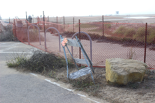
After the storms, which also wrought other damage to City facilities, the City fenced off that portion of the Harborwalk deeming it unsafe, and the public has not been able to use it since.
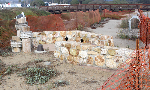
Plastic net fencing strung between iron posts mars an otherwise scenic spot.
Normally, there is about 250 yards of beach between the Pit and the ocean and the creek meanders through the creek channel and pools on the beach, but that storm/king tide was strong enough to push the stream through the sand and erode the bank.
The Harborwalk damage now has become mired in a dispute over what caused the erosion, and what to do to protect the creek bank from future erosion.
Path Approved With Bridge
The “dog-leg” the Harborwalk takes as it approaches the Morro Creek Bridge was approved and built as part of the 2014 bridge project and so comes under the terms of that project; including the Commission’s policy on sea level rise, namely “planned retreat” from the coast.
It’s the same policy that drove the City to build a new sewer treatment plant well away from so-called coastal hazards like tsunami zones, flood plains and sea level rise.
The bridge project was actually approved under a waiver from the Coastal Commission’s executive director (Waiver No. 3-13-1339-W), which reads in part, “The proposed multi-use trail will connect with the proposed bridge and provide for a pedestrian and bicycle crossing of Morro Creek where none exists now. Thus, the proposed project will increase and enhance the scope of public access and recreational opportunities in this heavily-used visitor-serving area.”
The waiver went to the commission for approval in May 2014.
Storm Damage Was Extensive
The bridge was completed in 2016 and just months later, the area was hit with fierce winter storms that wrought havoc up and down the Central Coast including Paul’s Slide, a landslide that closed Hwy 1 in Big Sur for nearly a year.
The City’s been trying to fix the damages at home.
“The repair work for this erosional damage was included in a request for assistance submitted to FEMA and CAL-OES for this declared disaster,” City Engineer Rob Livick said. “The City received funding for the erosional damage along with funding to reimburse work to remove downed trees, repairs to the Monte Young Park fence, the Black Hill radio repeater and reimbursement for overtime and call-back pay.
“The amount that FEMA calculated to restore the Morro Creek stream bank was $73,000 and the City received that funding in Spring 2018.”
Guidance Sought for Repairs
With its FEMA award on the way, the City sought guidance on how to proceed from Coastal Commission staff in Santa Cruz.
In a May 3, 2018 email from Morro Bay planner, Cindy Jacinth to Commission staffers, Sarah Carvill and Kevin Kahn and obtained by Estero Bay News in a Public Records Act request, Jacinth wrote, that during that winter’s storm events, “a portion of the public access trail experienced some slope failure, for which the City is seeking to repair this area. Our Public Works Department is working with FEMA for funding of this repair & maintenance effort.”
Jacinth goes on to explain that the City would consult with State Fish & Wildlife, and the Regional Water Quality Control Board, and attached results from a hydrology report done on the failed slope with the email.
In a next day response, Kahn asks, “So is the recommended fix to install 2,750 (110 x 25) square feet (6,000 cubic yards) of RSP to protect the trail/parking from further creek erosion?” (RSP is “rock slope protection,” essentially the City planned to shore up the creek bank with rocks.)
The subject apparently lay dormant until Oct. 19, 2018, when with FEMA money in hand the City again contacted the Commission staff. “We would like to proceed with the work to repair the creek before the winter,” Jacinth wrote. “I had emailed last spring on this to determine required Coastal steps/processing. This is an area where we previously received a waiver #3-13-1339-W for multi-use public access trail and bike path that is now experienced slope failure from last winter’s rains.”
Emails Lay Out Position
In an internal email, Carvill writes to Kahn, “We were going to discuss this with Dan [Carl, assistant director] at a planner check-in before advising the City, but I don’t think that ever happened. We do have a record of asking the City what their plan would be if the path was damaged by storms/SLR/flooding.
“The City at one point replied: ‘The response to events such as these would be to retreat and relocate facilities to allow the natural processes to continue. Shoreline protection and channel armoring would not be pursued to protect the improvements in place.’”
That was apparently in reference to conditions understood with the Commission’s waiver, including the sea level rise policy, i.e. not to make repairs or armor the coast but instead rebuild away from the ocean.
“I noted that ‘events such as these’ does refer to ‘a succession of flood events over time,’” Carvill wrote, “and the foregoing paragraphs discuss approaches to erosion events caused by single storms, for which ‘exigent repair projects’ are the favored response. I was concerned that they technically didn’t commit to no future armoring under any circumstances, but you felt that we had enough to say that they agreed to no future armoring.
“Should I write Cindy and say we don’t think armoring is authorized for this development? Or just bring it to Dan on 11/1?”
Kahn’s reply was, “I think we tell them that our take is that armoring, per the waiver [and regardless of the waiver, it isn’t existing development, but rather new development approved only 4-years ago, where there is ample room for relocation inland], is not allowed here to address the erosion issues. They need to look at soft alternatives, such as vegetation and drainage improvements, as well as relocation/removal. But putting in all of that RSP along the mouth of an unarmored creek is not going to fly. Plus, wouldn’t this be in our CDP jurisdiction?”
Questions Went Unanswered
It should be noted that EBN also sent a number of questions to the commission staff along with the records request, but only the waiver report and one email train were provided.
Among our unanswered questions was how they concluded that sea level rise was to blame for this erosion? Did they get a scientific opinion that this was caused by sea level rise?
And also, didn’t the Commission have a fiduciary responsibility to see that public facilities, which they approved, are maintained and repaired?
EBN also pointed out that this stretch of Morro Creek was built by the Army Corps of Engineers in the 1940s, in order to re-channel the creek and drain what is now the power plant property for a military base. It is lined on both sides with boulders blasted from Morro Rock and is not “unarmored.”
For the City’s part, Livick told EBN, “Coastal Staff contend the damage was due to climate change. City Staff is of the opinion that the damage was due to a high stream flow due to a storm combined with a high tide.”
City’s Not Given Up
Despite the apparent stalemate, the City hasn’t given up. “In order to receive a waiver to construct the path and bridge, the City agreed [in a letter previously transmitted] to not pursue armoring and reconstruction if damage was due to climate change, but would perform repairs if the damage was due to events such as high stream flow causing erosional damage.
“Staff has prepared two designs and shared those with coastal staff to no avail, they will not support any repair. Our next step was to submit an application and argue the issue in front of the commission.”
But then COVID-19 hit the City like a big storm on top of a king tide, and the Harborwalk repairs have been replaced by other priorities.
“Due to loss of staff resources and higher priority projects,” Livick said, “staff has been unable to complete the work necessary for the Coastal Development permit application.”
Of course, now the FEMA money isn’t likely to be enough. “The project does remain on the work plan,” Livick said, “and once resources become available, continue working on the project although it is unlikely the FEMA funding will be sufficient to complete the required planning, environmental, design, permitting and ultimately construction work necessary to facilitate the repair.”
Site Looks Bad
So as government agencies try to figure out a way forward, a segment of taxpayer-funded public-use pathway remains closed to the public, an apparent victim of climate change policy.
Today, a small flock of mallard ducks waddles in the stinky, stagnant creek water below.
The fencing has fallen down; a City barricade appears to have been run over and stood back up, bent and broken; and a scenic portion of what has been a wonderful addition to the waterfront — the Harborwalk — looks abandoned, taken over by gulls and crows, and overgrown with weeds.